News
Groundbreaking Shoreline Interactive Map Launches

Residents Empowered to Access over 300 Public Shoreline Access Points in the Cayman Islands
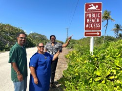
The Ministry of District Administration and Lands (MDAL) is thrilled to announce the official launch of the Shoreline Interactive Map (IMAP), an innovative online navigation tool accessible at www.gov.ky/shoreline. It provides users with a dynamic platform to locate public pedestrian pathways to the shoreline and public beach areas across the three Cayman Islands.
Premier and Minister of Lands, Hon. Juliana O’Connor-Connolly shared her sentiments on the launch of the Shoreline IMAP, explaining how it represents a pivotal step toward empowering residents, “Whether you are a resident or a visitor, the Shoreline IMAP offers an experience for understanding and accessing our coastal treasures by leveraging technology, all while preserving and promoting our deep-rooted maritime culture.”
For MDAL, this transformative initiative is aimed at enhancing public knowledge, appreciation, and stewardship of public rights of ways to the shoreline by the Public Lands Inspectorate (PLI). The online tool will be supported by a six-month (May to Nov 2024), public engagement campaign led by the Public Lands Inspectorate, the organisation with responsibility for enforcing the laws relating to the application and use of public lands.
Innovation Method in Action
Wilbur Welcome, MDAL’s Acting Chief Officer and the driving force behind this groundbreaking project, emphasizes the application of The Innovator’s Method in crafting the Shoreline IMAP. Discussing the project, Welcome elaborates on its current status, highlighting it as phase 1—a prototype paving the way for a more comprehensive solution. He articulates, 'Innovation transcends mere novelty; it entails tackling real-world challenges amidst uncertainty through an iterative approach. Recognizing the pressing concerns voiced by our stakeholders, notably the lack of accessible shoreline information and navigational difficulties in specific areas, we embarked on delivering swift yet cost-effective solutions. Our aim was not only to address these pain points but also to gather actionable insights from our users, ensuring a remarkable end-product. The Shoreline IMAP fulfills these objectives, and we eagerly invite public engagement as we evolve towards a standalone smartphone application boasting enhanced functionality.'"
MDAL seeks the public’s engagement of the IMAP tool to help test and give feedback towards the development of phase 2 of the project which is scheduled for launch in 2025.
Key Features of the Shoreline IMAP Prototype:
Enhanced Public Awareness:
-
- It provides the public with accurate location information on more than 300 public rights-of-ways to the shoreline.
Convenience
-
- It empowers users with free information at their fingertips.
Digital Empowerment
-
- Users can easily locate public access points to the shoreline and explore amenities using their digital communication devices.
- It bridges the gap between vast amounts of data and user-friendly navigation.
Community Participation:
-
- It generates real-time user insights through Google Analytics.
- The Shoreline IMAP campaign will provide opportunities for public feedback through online surveys.
- The public will play an active role in reporting blocked shoreline access points directly to the Public Lands Inspectorate (PLI).
Preserving Our Collective Culture:
-
- Recognizing the shoreline as part of our collective culture, it fosters stewardship by all.
- It facilitates responsible use and appreciation of our natural resources.
Join the Movement!
MDAL invites residents—boaters, fitness enthusiasts, families, explorers and beach lovers—to engage with the Shoreline IMAP by testing it out the tool. Discover, explore, report, and celebrate our shoreline accesses. With over 300 access points, public involvement becomes crucial in safeguarding our shoreline heritage. Together, we can ensure that future generations inherit the same pristine beauty that defines the Cayman Islands.
About Ministry of District Administration and Lands (MDAL)
The Ministry of District Administration and Lands is committed to environmental stewardship, digital empowerment, and community participation. Our vision is a future where the beauty and benefits of the Cayman Islands’ shoreline are universally recognized and preserved.
About Public Lands Inspectorate (PLI)
The Public Lands Inspectorate under the oversight of MDAL, is dedicated to enforcing the laws outlined in the Public Lands Act (2020 Revision) and the Public Lands Regulations, 2021. Their main job involves overseeing how public lands are used. To report blocked shoreline access points, contact the Public Lands Inspectorate by email at PLCInspectorate@gov.ky or by phone at 9467110
Visit www.gov.ky/shoreline to learn more and to use the Shoreline IMAP.


