News
Hurricane Beryl Advisory Number 23

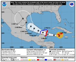
...WEATHER DETERIORATING IN THE CAYMAN ISLANDS WITH STRONG WINDS, DANGEROUS STORM SURGE, AND DAMAGING WAVES EXPECTED THERE LATER THIS MORNING...
SUMMARY OF 500 AM EDT...0900 UTC...INFORMATION ----------------------------------------------
LOCATION...18.5N 81.0W ABOUT 55 MI...90 KM SSE OF GRAND CAYMAN ABOUT 440 MI...705 KM ESE OF TULUM MEXICO MAXIMUM SUSTAINED WINDS...120 MPH...195 KM/H PRESENT MOVEMENT...WNW OR 285 DEGREES AT 20 MPH...31 KM/H MINIMUM CENTRAL PRESSURE...968 MB...28.59 INCHES WATCHES AND WARNINGS --------------------
CHANGES WITH THIS ADVISORY: The government of Jamaica has discontinued the Hurricane Warning for Jamaica. SUMMARY OF WATCHES AND WARNINGS IN EFFECT: A Hurricane Warning is in effect for... * Grand Cayman * Little Cayman and Cayman Brac * The coast of the Yucatan Peninsula of Mexico from Puerto Costa Maya to Cancun, including Cozumel A Hurricane Watch is in effect for... * The coast of the Yucatan Peninsula of Mexico south of Puerto Costa Maya to Chetumal * The coast of the Yucatan Peninsula of Mexico north of Cancun to Cabo Catoche A Tropical Storm Warning is in effect for... * The coast of the Yucatan Peninsula of Mexico south of Puerto Costa Maya to Chetumal * The coast of the Yucatan Peninsula of Mexico north of Cancun to Campeche A Tropical Storm Watch is in effect for... * Coast of Belize from south of Chetumal to Belize City A Hurricane Warning means that hurricane conditions are expected somewhere within the warning area. Preparations to protect life and property should be rushed to completion. A Tropical Storm Warning means that tropical storm conditions are expected somewhere within the warning area within 36 hours. A Hurricane Watch means that hurricane conditions are possible within the watch area, generally within 48 hours. A Tropical Storm Watch means that tropical storm conditions are possible within the watch area, generally within 48 hours. Interests elsewhere in the northwestern Caribbean Sea and the western Gulf of Mexico, including southern Texas, should closely monitor the progress of Beryl. For storm information specific to your area, please monitor products issued by your national meteorological service. DISCUSSION AND OUTLOOK ---------------------- At 500 AM EDT (0900 UTC), the center of Hurricane Beryl was located near latitude 18.5 North, longitude 81.0 West. Beryl is moving toward the west-northwest near 20 mph (31 km/h). A westward to west- northwestward motion is expected during the next day or two, taking the core of Beryl just south of the Cayman Islands early today and over the Yucatan Peninsula early Friday. Beryl is expected to emerge over the southwestern Gulf of Mexico Friday night and turn northwestward. Maximum sustained winds have decreased to near 120 mph (195 km/h) with higher gusts. Beryl is a category 3 hurricane on the Saffir-Simpson Hurricane Wind Scale. Weakening is forecast during the next day or two. However, Beryl is forecast to be near major hurricane intensity today as it passes by the Cayman Islands. Additional weakening is expected thereafter, though Beryl is forecast to remain a hurricane until it makes landfall on the Yucatan Peninsula. Hurricane-force winds extend outward up to 45 miles (75 km) from the center and tropical-storm-force winds extend outward up to 175 miles (280 km). The estimated minimum central pressure is 968 mb (28.59 inches). HAZARDS AFFECTING LAND ---------------------- Key messages for Beryl can be found in the Tropical Cyclone Discussion under AWIPS header MIATCDAT2 and WMO header WTNT42 KNHC. WIND: Hurricane conditions are expected to reach the Cayman Islands soon, with tropical storm conditions ongoing. Hurricane conditions are expected in the hurricane warning area on the Yucatan Peninsula late today or early Friday. Winds are expected to first reach tropical storm strength later today, making outside preparations difficult or dangerous. Hurricane conditions are possible in the hurricane watch area along the east coast of the Yucatan Peninsula as early as late today. Tropical storm conditions are expected in the tropical storm warning area of the Yucatan Peninsula late today. Tropical storm conditions are possible in the tropical storm watch area along portions of the coast of Belize by late today or early Friday. STORM SURGE: Storm surge could raise water levels by as much as 2 to 4 feet above normal tide levels in areas of onshore winds along the immediate coast of the Cayman Islands. Storm surge could raise water levels by as much as 4 to 6 feet above ground level in areas of onshore winds along the east coast of the Yucatan Peninsula within the hurricane warning area and by as much as 1 to 3 feet above ground level along the west coast of the Yucatan Peninsula in the tropical storm warning area. Near the coast, the surge will be accompanied by large and destructive waves. RAINFALL: Beryl is expected to produce rainfall totals of 4 to 6 inches over the Cayman Islands today. Over the Yucatan Peninsula, Beryl is expected to produce rainfall totals of 4 to 6 inches, with localized amounts of 10 inches, later today into Friday. Scattered instances of flash flooding are anticipated. For a complete depiction of forecast rainfall and flash flooding associated with Hurricane Beryl, please see the National Weather Service Storm Total Rainfall Graphic, available at hurricanes.gov/graphics_at2.shtml?rainqpf SURF: Large swells generated by Beryl are currently impacting portions of the coast of Jamaica, Cuba, and the Cayman Islands. These swells are expected to spread to the Yucatan Peninsula and portions of Central America later today and to eastern Mexico and much of the Gulf Coast of the U.S. by late Friday. These swells are expected to cause life-threatening surf and rip current conditions. Please consult products from your local weather office. NEXT ADVISORY ------------- Next intermediate advisory at 800 AM EDT. Next complete advisory at 1100 AM EDT.


