News
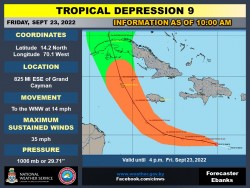
TD 9 - 10 a.m. Update - 23/9/22

The Cayman Islands Government has issued a Hurricane Alert for the Cayman Islands.
The Cayman Islands National Weather Service will continue to monitor the progress of this system.
The depression remains highly sheared this morning. Visible satellite imagery and data from an Air Force Reserve Hurricane Hunter aircraft indicate the center of the system is still exposed to the east of the associated deep convection.
The long-term motion of the depression is still west-northwestward at 12 kt. The cyclone is expected to move more westward over the next 24-36 h as a narrow low- to mid-level ridge builds to the north of the system.
The moderate to strong deep-layer northeasterly shear over the cyclone is expected to persist through tonight, so only slight strengthening is forecast through early Saturday. But once the shear decreases to less than 10 kt this weekend, more significant intensification is forecast as the cyclone moves over SSTs in excess of 30 deg C.


