News
Tropical Depression 9 Update from the National Hurricane Center

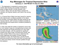
The organization of the depression has slightly improved since this morning. The low-level center has been decoupled from the deep convection for much of the day, but in recent satellite imagery it appears the center may be drawing closer to a more recent burst of convective activity. Unfortunately, earlier scatterometer data missed the center of the cyclone, and the satellite intensity estimates still range from 25-35 kt. The initial intensity is held at 30 kt for this advisory, and an Air Force Hurricane Hunter aircraft is on its way to investigate the system this evening. The system is still moving west-northwestward at 290/13 kt, but it is expected to turn westward tonight and continue on that heading through Saturday as a ridge develops to its north. Then, a deep- layer trough over the eastern U.S. is forecast to erode the ridge into early next week. This should result in a turn toward the northwest and north-northwest while the cyclone passes near the Cayman Islands early Monday and approaches western Cuba Monday night. Once again, the global models have shifted westward this cycle during this period, and there remains increased track uncertainty late in the forecast period once the cyclone emerges into the southeastern Gulf of Mexico. The latest NHC track forecast has been adjusted westward from 48-120 h, and it lies near or slightly east of the latest track consensus aids. Recent satellite trends suggest the cyclone may already be nearing a lower shear environment, and once that occurs, the atmospheric and oceanic conditions appear very conducive for strengthening through early next week. As the cyclone moves within a moist and unstable environment over sea-surface temperatures greater than 30 deg C, it is forecast to rapidly intensify over the northwestern Caribbean Sea and continue strengthening while it approaches western Cuba on Monday night. The very warm waters of the southeastern Gulf of Mexico should allow for more strengthening once it crosses Cuba, and the NHC forecast once again shows the system approaching the Florida peninsula as a major hurricane by the middle of next week. Based on the latest forecast, a Hurricane Watch has been issued for the Cayman Islands, and a Tropical Storm Watch has been issued for Jamaica. Key Messages: 1. The depression is expected to produce heavy rainfall, flash flooding and possible mudslides in areas of higher terrain in Aruba, Bonaire, and Curacao. Heavy rains are also likely to spread into Jamaica, the Cayman Islands, and Cuba in the coming days. 2. A Tropical Storm Watch has been issued for Jamaica, with tropical storm conditions possible on the island by Sunday. A Hurricane Watch has been issued for the Cayman Islands, with hurricane conditions possible by early Monday and tropical storm conditions possible by late Sunday. 3. Early next week the system is forecast to move near or over western Cuba as a strengthening hurricane and then approach the Florida peninsula at or near major hurricane strength, with the potential for significant impacts from storm surge, hurricane-force winds, and heavy rainfall. While it is too soon to determine the exact magnitude and location of these impacts, residents in Cuba, the Florida Keys, and the Florida peninsula should ensure they have their hurricane plan in place and closely monitor forecast updates through the weekend.


