News
Tropical Storm Ian Public Advisory

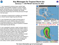
IAN EXPECTED TO RAPIDLY STRENGTHEN DURING THE NEXT SEVERAL DAYS AS IT MOVES ACROSS THE WESTERN CARIBBEAN SEA... SUMMARY OF 500 PM EDT...2100 UTC...INFORMATION
----------------------------------------------
LOCATION...14.3N 77.0W ABOUT 255 MI...410 KM S OF KINGSTON JAMAICA ABOUT 445 MI...715 KM SE OF GRAND CAYMAN MAXIMUM SUSTAINED WINDS...45 MPH...75 KM/H PRESENT MOVEMENT...W OR 265 DEGREES AT 16 MPH...26 KM/H MINIMUM CENTRAL PRESSURE...1003 MB...29.62 INCHES WATCHES AND WARNINGS
--------------------
CHANGES WITH THIS ADVISORY: The government of Jamaica has discontinued the Tropical Storm Watch for Jamaica. SUMMARY OF WATCHES AND WARNINGS IN EFFECT: A Hurricane Warning is in effect for... * Grand Cayman A Tropical Storm Watch is in effect for... * Little Cayman and Cayman Brac A Hurricane Warning means that hurricane conditions are expected somewhere within the warning area. A warning is typically issued 36 hours before the anticipated first occurrence of tropical-storm-force winds, conditions that make outside preparations difficult or dangerous. Preparations to protect life and property should be rushed to completion. A Tropical Storm Watch means that tropical storm conditions are possible within the watch area, generally within 48 hours. Interests in western and central Cuba, the Florida Keys, and the Florida peninsula should monitor the progress of Ian. For storm information specific to your area, please monitor products issued by your national meteorological service. DISCUSSION AND OUTLOOK
----------------------
At 500 PM EDT (2100 UTC), the center of Tropical Storm Ian was located near latitude 14.3 North, longitude 77.0 West. Ian is moving toward the west near 16 mph (26 km/h), and this general motion is expected to continue through early Sunday. A turn toward the northwest and north-northwest is forecast on Sunday and Monday, followed by a northward motion on Tuesday. On the forecast track, the center of Ian is forecast to pass well southwest of Jamaica on Sunday, and pass near or west of the Cayman Islands Sunday night and early Monday. Ian will then move near or over western Cuba late Monday and emerge over the southeastern Gulf of Mexico on Tuesday. Data from an Air Force Reserve Hurricane Hunter aircraft indicate that maximum sustained winds remain near 45 mph (75 km/h) with higher gusts. Significant strengthening is forecast during the next few days. Ian is forecast to become a hurricane by late Sunday and a major hurricane by late Monday or early Tuesday. Tropical-storm-force winds extend outward up to 60 miles (95 km) from the center. The estimated minimum central pressure is 1003 mb (29.62 inches). HAZARDS AFFECTING LAND
----------------------
Key messages for Ian can be found in the Tropical Cyclone Discussion under AWIPS header MIATCDAT4 and WMO header WTNT44 KNHC and on the web at hurricanes.gov/text/MIATCDAT4.shtml. WIND: Hurricane conditions are expected to reach Grand Cayman by early Monday, with tropical storm conditions expected by Sunday night. Tropical storm conditions are possible on Little Cayman and Cayman Brac by Sunday night. RAINFALL: Ian is expected to produce the following rainfall: Southern Haiti and Southern Dominican Republic: 2 to 4 inches, with local maxima up to 6 inches Jamaica and the Cayman Islands: 3 to 6 inches, with local maxima up to 10 inches Western Cuba: 4 to 8 inches, with local maxima up to 12 inches Florida Keys and southern Florida: 2 to 4 inches, with local maxima up to 6 inches through Tuesday evening These rains may produce flash flooding and mudslides in areas of higher terrain, particularly over Jamaica and Cuba. Flash and urban flooding is possible with rainfall across the Florida Keys and the Florida peninsula through mid next week. Additional flooding and rises on area streams and rivers across Florida cannot be ruled out through next week given already saturated antecedent conditions. STORM SURGE: Storm surge could raise water levels by as much as 2 to 4 feet above normal tide levels along the immediate coast in areas of onshore winds in the Cayman Islands Sunday night into Monday. Localized coastal flooding is possible along the coast of Jamaica in areas of onshore winds on Sunday. SURF: Swells generated by Ian will begin affecting Jamaica and the Cayman Islands on Sunday and spread westward to Cuba by Monday. These swells are likely to cause life-threatening surf and rip current conditions. Please consult products from your local weather office.
NEXT ADVISORY -------------
Next intermediate advisory at 800 PM EDT. Next complete advisory at 1100 PM EDT.


