News
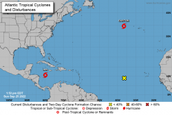
Tropical Storm Ian Public Advisory 1PM

SUMMARY OF 200 PM EDT...1800 UTC...INFORMATION
----------------------------------------------
LOCATION...15.7N 80.0W ABOUT 265 MI...425 KM SSE OF GRAND CAYMAN ABOUT 540 MI...865 KM SE OF THE WESTERN TIP OF CUBA MAXIMUM SUSTAINED WINDS...50 MPH...85 KM/H PRESENT MOVEMENT...WNW OR 300 DEGREES AT 12 MPH...19 KM/H MINIMUM CENTRAL PRESSURE...1001 MB...29.56 INCHES WATCHES AND WARNINGS
--------------------
CHANGES WITH THIS ADVISORY: The government of the Cayman Islands has issued a Tropical Storm Watch for Little Cayman and Cayman Brac. SUMMARY OF WATCHES AND WARNINGS IN EFFECT: A Hurricane Warning is in effect for... * Grand Cayman * Cuban provinces of Isla de Juventud, Pinar del Rio, and Artemisa A Tropical Storm Warning is in effect for... * Cuban provinces of La Habana, Mayabeque, and Matanzas A Tropical Storm Watch is in effect for... * Little Cayman and Cayman Brac A Hurricane Warning means that hurricane conditions are expected somewhere within the warning area. A warning is typically issued 36 hours before the anticipated first occurrence of tropical-storm- force winds, conditions that make outside preparations difficult or dangerous. Preparations to protect life and property should be rushed to completion. A Tropical Storm Warning means that tropical storm conditions are expected somewhere within the warning area within 36 hours. A Tropical Storm Watch means that tropical storm conditions are possible within the watch area, generally within 48 hours. Interests in central Cuba, the Florida Keys, and the Florida peninsula should monitor the progress of Ian. For storm information specific to your area, please monitor products issued by your national meteorological service.
DISCUSSION AND OUTLOOK
----------------------
At 200 PM EDT (1800 UTC), the center of Tropical Storm Ian was located near latitude 15.7 North, longitude 80.0 West. Ian is moving toward the west-northwest near 12 mph (19 km/h). A turn toward the northwest is expected this evening, followed by a north-northwestward motion on Monday and a northward motion on Tuesday with a slightly slower forward speed. On the forecast track, the center of Ian is expected to pass well southwest of Jamaica this evening, and pass near or west of the Cayman Islands early Monday. Ian will then move near or over western Cuba Monday night and early Tuesday and emerge over the southeastern Gulf of Mexico on Tuesday. Maximum sustained winds are near 50 mph (85 km/h) with higher gusts. Rapid strengthening is forecast to begin tonight. Ian is expected to become a hurricane by early Monday and reach major hurricane strength Monday night or early Tuesday before it reaches western Cuba. Tropical-storm-force winds extend outward up to 60 miles (95 km) from the center. The estimated minimum central pressure is 1001 mb (29.56 inches).


