News
Tropical Storm Ian Public Advisory 7pm Update

SUMMARY OF 800 PM EDT...0000 UTC...INFORMATION
----------------------------------------------
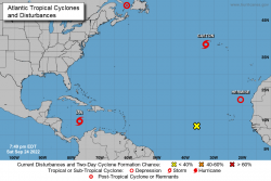
LOCATION...14.6N 77.1W ABOUT 230 MI...370 KM S OF KINGSTON JAMAICA ABOUT 430 MI...690 KM SE OF GRAND CAYMAN MAXIMUM SUSTAINED WINDS...45 MPH...75 KM/H PRESENT MOVEMENT...W OR 275 DEGREES AT 14 MPH...22 KM/H MINIMUM CENTRAL PRESSURE...1002 MB...29.59 INCHES WATCHES AND WARNINGS
--------------------
CHANGES WITH THIS ADVISORY:
None. SUMMARY OF WATCHES AND WARNINGS IN EFFECT: A Hurricane Warning is in effect for... * Grand Cayman A Tropical Storm Watch is in effect for... * Little Cayman and Cayman Brac A Hurricane Warning means that hurricane conditions are expected somewhere within the warning area. A warning is typically issued 36 hours before the anticipated first occurrence of tropical-storm-force winds, conditions that make outside preparations difficult or dangerous. Preparations to protect life and property should be rushed to completion. A Tropical Storm Watch means that tropical storm conditions are possible within the watch area, generally within 48 hours. Interests in western and central Cuba, the Florida Keys, and the Florida peninsula should monitor the progress of Ian. For storm information specific to your area, please monitor products issued by your national meteorological service.
DISCUSSION AND OUTLOOK
----------------------
At 800 PM EDT (0000 UTC), the center of Tropical Storm Ian was located by a NOAA Hurricane Hunter surveillance aircraft near latitude 14.6 North, longitude 77.1 West. Ian is moving toward the west near 14 mph (22 km/h), and this general motion is expected to continue through early Sunday. A turn toward the northwest and north-northwest is forecast on Sunday and Monday, followed by a northward motion on Tuesday. On the forecast track, the center of Ian is forecast to pass well southwest of Jamaica on Sunday, and pass near or west of the Cayman Islands Sunday night and early Monday. Ian will then move near or over western Cuba late Monday and emerge over the southeastern Gulf of Mexico on Tuesday. Maximum sustained winds are near 45 mph (75 km/h) with higher gusts. Significant strengthening is forecast during the next few days. Ian is forecast to become a hurricane by late Sunday and a major hurricane by late Monday or early Tuesday. Tropical-storm-force winds extend outward up to 60 miles (95 km) from the center. Dropsonde data from the NOAA surveillance aircraft indicate that the minimum central pressure is 1002 mb (29.59 inches).


