News
Tropical Storm Karen 23-Sept-2019 10 AM Update

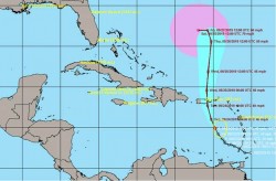
At 500 AM AST (0900 UTC) the center of Tropical Storm Karen was located near latitude 13.6 North longitude 63.9 West. Karen is moving toward the northwest near 8 mph (13 km/h) and this general motion is forecast to continue today. A turn toward the north is expected on Tuesday. On the forecast track the center of Karen will move across the eastern Caribbean Sea through tonight. On Tuesday Karen is expected to pass near or over Puerto Rico and the Virgin Islands. Maximum sustained winds are near 40 mph (65 km/h) with higher gusts. Some fluctuations in strength will be possible during the next 48 hours due to strong upper-level winds. Tropical-storm-force winds extend outward up to 105 miles (165 km) mainly northeast through southeast of the center. The estimated minimum central pressure is 1007 mb (29.74 inches).


